
|
 |
 |
|
|
|
The Modern East End
by Johnno
The murders committed by Jack the Ripper were perpetrated in a small section
of the East End of London during the autumn of 1888. The East End at the
time was one of the worst slums in London, and remains somewhat run down in
parts even nowadays.
During May and June of 1999, and July of 2000, John paid numerous visits
to the areas in which the crimes took place over 111 years ago. He visited
the scenes of each murder: Buck's Row (now Durward Street) in Whitechapel,
Hanbury Street in Spitalfields, Berner Street (now Henriques Street) in
Whitechapel, Mitre Square, Aldgate, and Dorset Street (now an un-named
thoroughfare) in Spitalfields. He also visited many other streets and
scenes which were of significance to the Ripper saga, and also some which
were not particularly significant, but were commonly traversed during the
time of the murders and would have been familiar to the killer and the
women he murdered.
Below are the photographs taken during those visits. Click each image
for a full-size view.
|
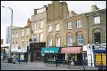
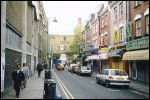
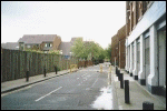
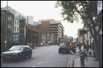
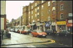
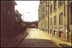
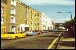
A view of modern Bethnal Green Road, Bethnal Green, looking in a
westward direction towards Shoreditch and Spitalfields. Many of
the old buildings can still be seen in this area. Taken: Thursday,
May 13, 1999.
|
|
|
|
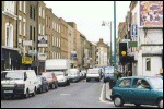
A view of modern Brick Lane, Spitalfields. This view looks south
from the corner of Bethnal Green Road and Brick Lane. Taken:
Thursday, May 13, 1999.
|
|
|
|
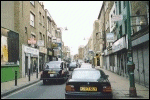
A view of modern Brick Lane, Spitalfields. This view looks
north along the popular market street towards Shoreditch.
Taken: Thursday, May 13, 1999.
|
|
|
|
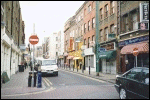
A view of modern Brick Lane, Spitalfields. This view looks
south and was taken from the corner of Brick Lane and the
eastern section of Hanbury Street. Taken: Thursday, May
13, 1999.
|
|
|
|
Brick Lane, Spitalfields. This view looks north towards
Bethnal Green Road and was taken from the Hanbury Street
exit. Truman Brewery's building can be seen on the left
side of the photograph, as well as in the distance.
Taken: Thursday, May 13, 1999.
|
|
|
|
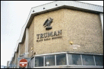
A north-westerly view of Truman Brewery on the northern corner
of Hanbury Street and Brick Lane, Spitalfields. Taken: Thursday,
May 13, 1999.
|
|
|
|
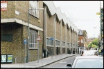
A view of Hanbury Street, Spitalfields. This view was taken
from Brick Lane and looks west towards Commercial Street.
Truman Brewery can be seen on the right (north) side of the
photograph, completely covering the exact location where 29
Hanbury Street once stood. Taken: Thursday, May 13, 1999.
|
|
|
|
A close-up view of the brickwork on the old buildings which
still remain on Hanbury Street. This view was taken from the
Brick Lane exit and looks towards the south side of Hanbury
Street. Taken: Thursday, May 13, 1999.
|
|
|
|
A view of Hanbury Street looking east from the Commercial Street
exit. Truman Brewery, which covers the location where number 29
once stood, can be seen on the left site of the picture. Taken:
Thursday, May 13, 1999.
|
|
|
|
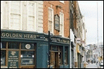
A view of the Golden Heart Pub in Spitalfields, one of the many
pubs in the area. The street sign out the front points towards
Brick Lane, Petticoat Lane Market, Liverpool Street Station,
Spitalfields Market and Christ Church. Taken: Thursday, May 13,
1999.
|
|
|
|
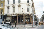
A view of the Ten Bells Pub on the corner of Commercial Street
and Fournier Street, Spitalfields. This view was taken from the
west side of Commercial Street and looks in an eastward direction
towards Fournier Street. Taken: Thursday, May 13, 1999.
|
|
|
|
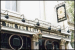
A close-up view of the sign on the Ten Bells Pub on Commercial
Street, Spitalfields. Christ Church can be seen in the far right
side of the picture. Taken: Thursday, May 13, 1999.
|
|
|
|
A view of Spitalfields Market on Commercial Street. The market
is a very short distance north of where Dorset Street once stood.
This photograph was taken from the east side of Commercial Street.
Taken: Thursday, May 13, 1999.
|
|
|
|
A view of Christ Church, Spitalfields. Christ Church is located
on the corner of Fournier Street and the east side of Commercial
Street. Taken: Thursday, May 13, 1999.
|
|
|
|
An eastward view along Fournier Street, Spitalfields. The Ten
Bells Pub is shown on the left (north) side of the shot, and
Christ Church is shown on the right (south) side. This photo
was taken from the west side of Commercial Street. Taken:
Thursday, May 13, 1999.
|
|
|
|
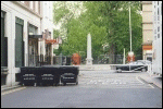
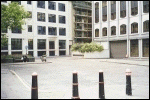
A westward view of the area which was once known as Dorset
Street, Spitalfields. The area is now a private alley running
between a carpark on the south side and warehouses on the north
side. A building which was once a women's refuge can be seen
on Crispin Street at the far end of the picture. Miller's Court
would have been along the stretch of the street now occupied by
the green shutter doors. Taken: Thursday, May 13, 1999.
|
|
|
|
An eastward view of the area which was once known as Dorset
Street, Spitalfields. Commercial Street and some of the ground
surrounding Christ Church can be seen at the far end of the
picture. Taken: Thursday, May 13, 1999.
|
|
|
|
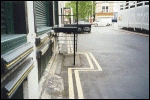
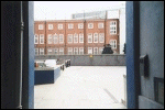
A close-up view of the approximate location of Miller's Court
in the area which was once known as Dorset Street, Spitalfields.
This view looks eastward towards Commercial Street. Taken:
Thursday, May 13, 1999.
|
|
|
|
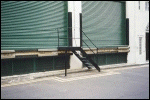
A view of the approximate location of Miller's Court. This
view looks slightly north-east. Taken: Thursday, May 13, 1999.
|
|
|
|
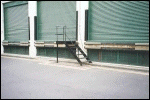
A view of the approximate location of Miller's Court from the
opposite angle, looking slightly north-west. Taken: Thursday,
May 13, 1999.
|
|
|
|
A view looking eastward down Flower and Dean Street (now called
Lolesworth Close), Spitalfields. This shot was taken from
Commercial Street. As can be seen from the picture, it is
largely an empty road. Taken: Thursday, May 13, 1999.
|
|
|
|
A view looking westward down Flower and Dean Street (now called
Lolesworth Close), Spitalfields. Commercial Street can be seen
at the end of the shot. Taken: Thursday, May 13, 1999.
|
|
|
|
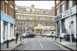
A view looking north along Commercial Street. It was taken
from the Flower and Dean Street exit. The white framework of
the carpark standing where Dorset Street once stood can be seen
at the far end of the picture. Taken: Thursday, May 13, 1999.
|
|
|
|
A view looking north along Commercial Street. It was taken from
Whitechapel High Street, Aldgate. It is a short three or four
minute walk north of here to Dorset Street and Hanbury Street
further north. Taken: Thursday, May 13, 1999.
|
|
|
|
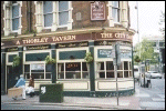
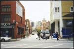
A view of the City Darts Pub, formerly known as the Princess
Alice, where "Leather Apron" was known to have drank.
The City Darts Pub is located on the corner of Commercial and
Wentworth Streets. Taken: Thursday, May 13, 1999.
|
|
|
|
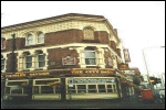
Another view of the City Darts Pub from the corner of Commercial
and Wentworth Streets. Taken: Thursday, May 13, 1999.
|
|
|
|
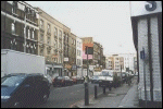
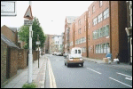
A westward view of Wentworth Street taken from the Commercial
Street end. building housing the City Darts Pub can just be
seen on the far right hand side. Taken: Thursday, May 13, 1999.
|
|
|
|
A northward view of Gunthorpe Street taken from the Whitechapel
High Street. Gunthorpe Street was formerly known as George Yard,
and it was at the far northern end (not seen here) that Martha
Tabram was murdered. Taken: Thursday, May 13, 1999.
|
|
|
|
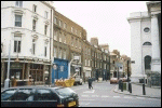
A view along Whitechapel High Street in Aldgate. Taken:
Thursday, May 13, 1999.
|
|
|
|
A view of Berner Street (now called Henriques Street) looking
in a southward direction from Commercial Road. Taken: Thursday,
May 13, 1999.
|
|
|
|
A view of Henriques Street looking in a south-western direction
from the Commercial Road end. it was further along the south-west
side near the corner of Fairclough Street that Dutfield's Yard
once stood. Taken: Thursday, May 13, 1999.
|
|
|
|
A view of one of the buildings along the north-western stretch
of Henriques Street. Taken: Thursday, May 13, 1999.
|
|
|
|
A north-west facing view of Henqriques Street, looking towards
Commercial Road at the far northern end. Taken: Thursday, May
13, 1999.
|
|
|
|
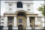
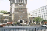
A view of St Botolph's Church from Houndsditch in Aldgate.
Taken: Thursday, May 13, 1999.
|
|
|
|
One of the only Ripper murder scenes to retain its name, this is
a view of Mitre Square, Aldgate. This view looks eastward at St
James's Passage, which was called Church Passage at the time of
the murder. The passage leads to Duke's Place and further into
Aldgate. Just behind the flower box and towards the fence is the
site where Catherine Eddowes was found murdered. Taken: Thursday,
May 13, 1999.
|
|
|
|
A close-up view of the modern buildings in Mitre Square which
now stand in the northern corner (opposite the corner where
Catherine Eddowes was found) in place of Kearley & Tonge's
buildings, which stood there in 1888. The entrance to the
Mitre Passage can be seen in the bottom left corner of the
picture. Taken: Thursday, May 13, 1999.
|
|
|
|
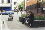
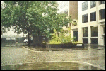
A full view of Mitre Square looking west from St James's Passage
(formerly Church Passage). The murder scene is to the left of
where the person is sitting. Mitre Street lies immediately
behind. As can be seen from the photo, Mitre Square still
retains its cobblestones, one of the very few reminders of what
the square would have looked like in 1888. Taken: Thursday, May
13, 1999.
|
|
|
|
A view of Mitre Square looking south-east from Mitre Passage.
The school can be seen in the background, and St James's Passage
(formerly Church Passage) can be seen to the left of the black
poles. The scene of the murder is now shown, but is off to the
right of the picture. Taken: Thursday, May 13, 1999.
|
|
|
|
A view of a rain-soaked Mitre Square looking south towards the
Mitre Street entrance. The murder scene is on the left side of
the flower box, under the trees, as shown from this angle.
Taken: Tuesday, June 29, 1999.
|
|
|
|
A close view of the doorway in which the infamous "Goulston
Street Grafitti" was discovered on the night of the double
murder. The area is now occupied by a fish-and-chips shop. The
original stone work above the doorway still remains intact.
Taken: Tuesday, June 29, 1999.
|
|
|
|
A north-eastward facing view of Goulston Street. The doorway
in which the graffiti was written is below a "To Let"
sign in the middle of the picture, above the closest red car
(not under the "To Let" sign in the far right side
of the picture). Taken: Tuesday, June 29, 1999.
|
|
|
|
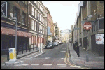
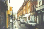
A view along the narrow and shabby Fashion Street in Spitalfields.
Many of the old buildings still remain, making Fashion Street one
of the more derelict streets in the area. Taken: Tuesday, June 29,
1999.
|
|
|
|
A view of Fashion Street from the opposite end. Taken:
Tuesday, June 29, 1999.
|
|
|
|
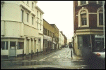
A view of Durward Street (formerly called Buck's Row), Whitechapel.
This view faces west and was taken from the Brady Street end.
Taken: Wednesday, June 23, 1999.
|
|
|
|
A view of Durward Street (formerly called Buck's Row), Whitechapel.
This view faces east and was taken from the Vallance Street end.
Mary Ann Nichols was discovered murdered not far along the right
side on the pavement beyond the brick wall with the fence. Taken:
Wednesday, June 23, 1999.
|
|
|
|
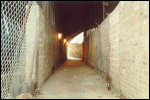
Swallow Gardens, the alleyway where Frances Coles was
murdered in 1891. Her murder has been attributed to
Jack the Ripper. Taken: Thursday, 27 July, 2000.
|
|
|
|
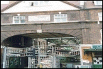
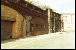
The railway arch on Pinchin Street, Whitechapel, under which
the "Pinchin Street Torso" was found. The unsolved
murder of the unidentified woman has been attributed to Jack
the Ripper. Taken: Thursday, 27 July, 2000.
|
|
|
|
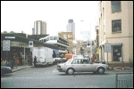
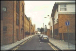
A southward view down Backchurch Lane, Whitechapel. Seen at
the far end of the street is Pinchin Street and the railway
arches, underneath one of which an unidentified woman was
found murdered and dismembered. Taken: Thursday, 27 July, 2000.
|
|
|
|
A close-up view of number 14 Batty Street, Whitechapel. This
building is not particularly significant to the Ripper case,
except that it is just a few doors up from number 22 Batty
Street, which in 1888 was a lodging house under surveillance
by the police. This building, with the year 1888 shown above
the door, is one of the few buildings in the area which was
built at the time of the murders. Taken: Thursday, 27 July,
2000.
|
|
|
|
A northward view along Batty Street, Whitechapel. It was on
this street that a mysterious lodger lived at the time of the
murders in 1888, and where, the previous year, Miriam Angel
was murdered by Israel Lipski at number 16. Taken: Thursday,
27 July,
2000.
|
|
|
|
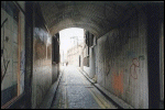
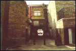
A view of Wood's Buildings, which leads from Winthrop Street
(parallel to Buck's Row [now called Durward Street]), into
Whitechapel High Street, Whitechapel. This grimy alleyway,
much the same as it was in 1888, was a very likely escape
route through which Jack the Ripper fled after murdering Mary
Ann Nichols a few yards away in Buck's Row. Taken: Thursday,
27 July, 2000.
|
|
|
|
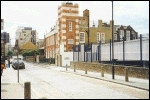
Crispin Street Women's Refuge. This Victorian building was once a
women's refuge in Spitalfields. It is located on Crispin Street,
a street perpendicular to the western end of Dorset Street. Taken:
Thursday, 27 July, 2000.
|
|
|
|
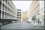
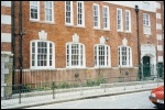
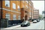
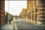
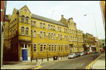
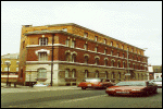
Commercial Street Police Station. This building is significant
not only because the murders were investigated there, and because
it is one of the very few buildings relating to the Ripper case
which is still there. This view looks north along Commercial
Street. Taken: Thursday, 27 July, 2000.
|
|
|
|
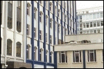
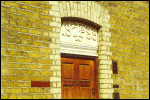
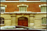
This shot shows the front door leading into Commercial Street
Police Station. The word "POLICE" still appears in
the concrete landing above the ground floor, although it may
be difficult to see in this photograph. Taken: Thursday, 27
July, 2000.
|
|
|
|
|
|
|